


 |
COUNTIES (Arizona)
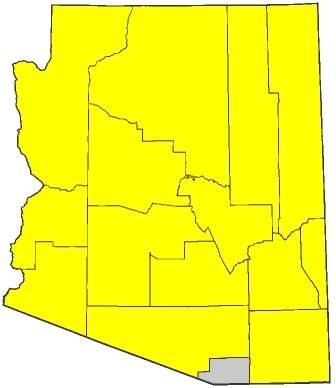
COUNTY          COUNTY SEAT     VISITED         INTERSTATES             US HIGHWAYS
Apache		Saint Johns        1986		40			60 64 160 180 191
Cochise		Bisbee		   1986		10			191
Coconino	Flagstaff	   1986		17 40			89 89A 160 180
Gila		Globe		   1993		none			60 70
Graham		Safford		   1993		none			70 191
Greenlee	Clifton		   1993		none			70 191
La Paz		Parker		   1986		10			60 95
Maricopa	PHOENIX		   1986		8 10 17			60 93
Mohave		Kingman		   1986		15 40			93
Navajo		Holbrook	   1986		40			60 160 163 180
Pima		Tucson		   1986		10 19			none
Pinal		Florence	   1986		8 10			60
Santa Cruz	Nogales		not yet		19			none
Yavapai		Prescott	   1986		17 40			93
Yuma		Yuma		   1986		8			95
---------------------------------------------------------------------------------------------
TOTAL: (14/15, 93.3%)				8 10 15 17 19 40	60 64 70 89 89A 93 95
									160 163 180 191
Complete routes through state:
- I-8: from California state line at Yuma to eastern terminus at I-10 in Casa Grande (181 miles)
- I-15: from Nevada state line at Mesquite to Utah state line near Saint George (29 miles)
- I-40: from California state line near Topock to New Mexico state line near Lupton (363 miles)
- US 70: from western terminus at US 60 in Globe to New Mexico state line near Duncan (123 miles)
Progress toward state route completion:
- I-10: from exit 112 (AZ 85) near Buckeye to exit 143A (I-17 North) in Phoenix, from exit 150B (end I-17) to exit 154 (US 60) in Tempe, and from exit 199 (I-8) near Casa Grande to New Mexico state line near San Simon (232 out of 399 miles)
- I-17: from southern terminus at I-10 exit 150 in Phoenix to I-10 exit 143 in Phoenix (6 out of 146 miles)
- I-19: intersected northern terminus at I-10 exit 260 in Tucson (0 out of 64 miles)
- US 60: from I-17 exit 200A in Phoenix to US 70 in Globe (91 out of 368 miles)
- US 64: (0 out of 4 miles)
- US 89: intersected southern terminus at I-40 exit 201 in Flagstaff (0 out of 139 miles)
- US 89A: (0 out of 87 miles)
- US 93: from I-40 exit 71 in the middle of nowhere to Nevada state line at Hoover Dam (94 out of 202 miles)
- US 95: (0 out of 125 miles)
- US 160: (0 out of 161 miles)
- US 163: (0 out of 24 miles)
- US 180: from I-40 exit 201 in Flagstaff to I-40 exit 252 in Winslow, and from I-40 exit 257 in Winslow to Petrified Forest National Park (105 out of 289 miles)
- US 191: from I-10 exit 331 near Cochise to I-10 exit 352 between Willcox and Bowie, from US 70 in Safford to US 70 in San Jose, and from I-40 exit 339 at Sanders to I-40 exit 333 at Chambers (38 out of 511 miles)
Also, I have driven significant portions of the following Arizona state routes:
- AZ-77: from US 70 in Pinal to US 60 in Globe, and from US 180 south of Holbrook to US 180 in Holbrook
- AZ-85: from I-8 exit 115 at Gila Bend to I-10 exit 112 near Buckeye
- AZ-95: from AZ-95S in Parker to I-40 exit 9 near Franconia
- AZ-95S: from AZ-95 in Parker to California state line at Parker
- AZ-99: from I-40 exit 252 west of Winslow to I-40 exit 245 in Winslow
- AZ-143: from exit 1 (I-10) in Tempe to exit 3 (Sky Harbor Boulevard) in Phoenix
- AZ-202: from exit 5 (AZ-143) in Phoenix to exit 7 (Scottsdale Road) in Tempe
Temporary back "button" until I update the sidebar
|