


 |
COUNTIES (Wyoming)
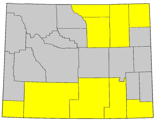
COUNTY		COUNTY SEAT		VISITED		INTERSTATES		US HIGHWAYS
Albany 		Laramie			   1988		80			30 287
Big Horn	Basin			not yet		none			14 14A 16 20 310
Campbell	Gillette		   1993		90			14 16
Carbon		Rawlins			   1988		80			30 287
Converse	Douglas			not yet		25			18 20 26 87
Crook		Sundance		   1993		90			14 16
Fremont		Lander			not yet		none			20 26 287
Goshen		Torrington		not yet		none			26 85
Hot Springs	Thermopolis		not yet		none			20
Johnson		Buffalo			   1993		25 90			16 87
Laramie		CHEYENNE		   1988		25 80 180		30 85 87
Lincoln		Kemmerer		not yet		none			26 30 89 189
Natrona		Casper			not yet		25			20 26 87 287
Niobrara	Lusk			not yet		none			18 20 85
Park		Cody			not yet		none			14 14A 16 20 212 310
Platte		Wheatland		not yet		25			26 87
Sheridan	Sheridan		   1993		90			14 14A 16 87
Sublette	Pinedale		not yet		none			189 191
Sweetwater	Green River		   1988		80			30 191
Teton		Jackson			not yet		none			26 89 189 191 287
Uinta		Evanston		   1988		80			189
Washakie	Worland			not yet		none			16 20
Weston		Newcastle		not yet		none			16 85
---------------------------------------------------------------------------------------------
TOTAL:(9/23, 39.1%)					25 80 90 180		14 14A 16 18
										20 26 30 85
										87 89 189 191
										212 287 310
Complete routes through state:
- I-80: from Utah state line near Evanston to Nebraska state line near Pine Bluffs (403 miles)
- I-90: from Montana state line near Parkman to South Dakota state line near Beulah (209 miles)
Progress toward state route completion:
- I-25: intersected northern terminus at I-90 exit 56B in Buffalo (0 out of 301 miles)
- I-180: intersected eastern terminus at I-80 exit 362 in Cheyenne (0 out of 1 mile)
- US 14: from I-90 exit 9 near Ranchester to I-90 exit 25 in Sheridan, from I-90 exit 128 in Gillette to I-90 exit 153 in Moorcroft, and from I-90 exit 189 in Sundance to South Dakota state line near Beulah (63 out of 449 miles)
- US 14A: (0 out of 103 miles)
- US 16: from I-90 exit 128 in Gillette to I-90 exit 153 in Moorcroft (25 out of 436 miles)
- US 18: (0 out of 99 miles)
- US 20: (0 out of 432 miles)
- US 26: (0 out of 476 miles)
- US 30: from I-80 exit 66 near Granger to I-80 exit 235 in Walcott, from I-80 exit 316 near Laramie to I-80 exit 358 in Cheyenne, from I-80 exit 370 near Cheyenne to I-80 exit 401 near Pine Bluffs WY (242 out of 452 miles)
- US 85: (0 out of 248 miles)
- US 87: from I-90 exit 56B in Buffalo to I-90 exit 44 near Story, and from I-90 exit 25 in Sheridan to Montana state line near Parkman (37 out of 359 miles)
- US 89: (0 out of 156 miles)
- US 189: from Utah state line near Evanston to I-80 exit 18 near Evanston (18 out of 216 miles)
- US 191: from I-80 exit 99 near Rock Springs to I-80 exit 104 in Rock Springs (6 out of 290 miles)
- US 212: (0 out of 55 miles)
- US 287: from I-80 exit 235 at Walcott to I-80 exit 215 in Rawlins (20 out of 423 miles)
- US 310: (0 out of 53 miles)
The US highways are not signed through Yellowstone National Park. Pretending they were, in the most sensible manner possible, the above would look like this for the affected routes:
- "US 16": from I-90 exit 128 in Gillette to I-90 exit 153 in Moorcroft (25 out of 500 miles) ("US 16" would begin at "US 212" in Tower Junction, south to join "US 20" and "US 89" in Canyon, south to Fishing Bridge where "US 89" would depart, and then, with "US 20," heading eastward out of the park to its current western terminus. This could also be "US 14," which also terminates for good at the park entrance but since US 16 terminates sooner heading east, I chose it.)
- "US 20": (0 out of 513 miles) ("US 20" would begin where it ends, at the western entrance to the park, joined with "US 191" and "US 287." The two routes would head east to Madison, where "US 191" and "US 287" would turn south, while "US 20" turns north. "US 20" would then pick up "US 89" in Norris, heading east to Canyon and picking up "US 16" as well, then turning south to Fishing Bridge. "US 89" would then head south, while "US 16" and "US 20" continue east to their current terminii at the park's eastern entrance.)
- "US 89": (0 out of 251 miles) ("US 89" would continue on from the southern entrance to the park, joined with "US 191" and "US 287." Heading north to West Thumb, "US 191" and "US 287" would split off to the west, while "US 89" turns northeast to join "US 16" and "US 20" at Fishing Bridge. From there, the three routes would head north to Canyon, where "US 16" veers north, and then after turning to the west, "US 20" splits off at Norris while "US 89" turns back to the north again. Finally, "US 89" would meet the new western terminus of "US 212" in Mammoth Hot Springs before exiting the park and rejoining its existing route into Montana.)
- "US 191": from I-80 exit 99 near Rock Springs to I-80 exit 104 in Rock Springs (6 out of 363 miles) ("US 191" and "US 287" would be joined for the duration of their passage through the park. From the southern entrance, joined also with "US 89," the route would head north to West Thumb where "US 89" would turn to the east. "US 191/287" would veer west here, then loop back north to Madison where they would join "US 20" and head west out of the park and to their existing path.)
- "US 212": (0 out of 82 miles) ("US 212" would begin at "US 89" in Mammoth Hot Springs, heading east to Tower Junction where it would intersect the new eastern terminus of "US 16." From there, "US 212" would continue solo to the Silver Gate exit of the park, and join its current routing.)
- "US 287": from I-80 exit 235 at Walcott to I-80 exit 215 in Rawlins (20 out of 491 miles) (see "US 191." The two routes would overlay for the duration of their stay in the park.)
Temporary back "button" until I update the sidebar
|